SoilRadar

Sensor and AI-supported decision support system for optimising nutrient and water management for field crops
SoilRadar project logo with three drop-shaped symbols representing a city, a house and agricultural plants. The project uses sensor and AI-supported systems to optimise nutrient and water management for field crops.
A field with young, green plants planted in rows in the foreground, with a sunset in the background. The image symbolises the SoilRadar project, which focuses on optimising nutrient and water management for field crops.

Support programme

This project is funded by the funding programme "Central Innovation for SMEs" (ZIM for short) as part of the ZIM Cooperation Network for Environmental Technology and Soil Recultivation as a cooperation project between a company and a research institution.
Logo of the funding partner.

Background

Determining the optimum time and quantity of nutrient and water application for a specific forecast period is one of the most important tasks in agriculture. Knowledge of the water content of the soil plays a special role here, e.g. in order to determine the necessary performance values for automatic irrigation and fertilisation tailored to this. Water-related soil characteristics are not only important for agricultural areas, but for all soils that have an influence on the formation of surface runoff or new groundwater.

In order to improve data collection and evaluation, a thorough understanding of the processes and mechanisms in the soil is required. The soil system as a water reservoir must be comprehensively understood and be able to be mapped using data technology. Among other things, the water cycle in the water catchment areas and the connection with plants such as field crops must be taken into account.

Objective

Development of a data management and decision support system to understand the soil as a water reservoir, e.g. to obtain implementation recommendations for the optimal nutrient and water supply of soils in agriculture or for preventive flood protection measures.

Contents

The focus of the project is on analysing the soil as a water reservoir. The conditions for both agricultural land and urban areas are taken into account.

A decision-making system is to be developed that accesses radar data on current precipitation, precipitation forecasts and important soil characteristics. The analysis is carried out with the help of AI algorithms.

A multi-stage implementation model is being developed that will reflect the consolidated target parameters:

  • The relationship between soil water balance and soil moisture
  • Water retention and water release behaviour of different soils
  • Transfer of nutrients/hazardous substances into the aquatic environment (groundwater, receiving waters)


Diagram of the SoilRadar project, which shows the role of soil as a water reservoir. It links agricultural areas and urban spaces with climate data, sensors, pollutant discharge, infiltration and surface runoff in order to optimise nutrient and water management. 
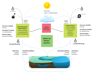
Fig.1: Task definition (Source: Prof. Müller-Czygan. Own illustration)

Project partners

Partner logo: TU Berlin

Berlin University of Technology
Faculty of Planning-Building-Environment
Institute of Civil Engineering
FG Urban Water Management
Secretariat TIB 1 B 16
13355 Berlin

Partner logo: Hydro Meteo GmbH

hydro & meteo GmbH
Breite Str. 6-8
D-23552 Lübeck, Germany

Partner logo: HST Systemtechnik

HST Systemtechnik GmbH & Co. KG
Heinrichsthaler Street 8
59872 Meschede

T+I Technologie- und InnovationsConsult GmbH
Schillstrasse 9
10785 Berlin

Addressed SDGs (Sustainable Development Goals)

Contact person

Institute Director and Research Group Leader:Prof Günter Müller-Czygan.

Prof Günter Müller-Czygan

Research group leader

Water infrastructure and digitalisation (DiWa)

Portrait of Andreas Aicher.

Andreas Aicher

Research assistant

Water infrastructure and digitalisation (DiWa)

Projects

Further research projects

The research here is tough.

Latest news

News and events

News about the inwa and its events.

en_GBEN